|
Pacific Information
|
GEOGRAPHY
 The Pacific is the world's largest ocean. Its area is greater than all of the world's dry land put together and covers one third of the earth's surface.
The average depth of the Pacific is just over 4,000m and it contains the deepest ocean trenches in the world. The Mindanao trench, close to the Philippines, is six and a half miles deep and the lowest point is the Marianas Trench.
The Pacific is almost triangular in shape, narrow in the Arctic north and broad in the Arctic south. In the west it touches Asia and Australia, in the east the Americas.
The rim of the Pacific Basin is ringed with volcanoes, from Alaska through the USA, Mexico and South America, then on to New Zealand and up to Japan and Russia. This is often called the "Ring of Fire" and includes about seventy-five per cent of all the world's volcanoes.
Volcanoes and earthquakes occur in areas of intense geological activity where the plates which make up the crust of the Earth, floating on the molten core, move against each other.
The Pacific Ocean has many thousands of islands. In the west, there are large islands such as Japan, Taiwan, Borneo and New Guinea, then there are the smaller islands of Polynesia (whose name means many islands) and Tahiti. Further away to the east are isolated islands such as Pitcairn, Easter Island and the Galapagos.
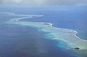
The Pacific's thousands of small islands are of two types: many are high and volcanic and others are low and formed on the top of submerged volcanoes. These, atolls as they are called, are coral islands and are made by coral polyps. Because the coral grows on the ocean side and dies in the centre, the island grows outwards in a ring shape.
TIDES/CURRENTS/TEMPERATURE
In the Pacific the systems of winds and currents follow a similar pattern to those of the Atlantic, with clockwise movement in the Northern Hemisphere and anti-clockwise in the South. Between the two run the Equatorial Currents. The North Equatorial Current, running 9,000 miles from Panama to the Philippines is the longest westerly running current in the world.
When the North Equatorial Current reaches Japan it turns north and is known as the Japan Current. The Japan Current is the west Pacific's counterpart of the Gulf Stream: when it meets the cold waters of the Arctic, fogs and storms are caused, just as they are at the meeting of the Labrador Current and the Gulf Stream.
In the southern half of the ocean the Humboldt Current flows north along the coast of South America. The cold mineral rich waters support many millions of small fish, which are eaten by larger fish and seabirds.
At regular intervals a huge area of the Pacific becomes warmer. Because warm water rises above cold, the sea-level increases. This change in temperature and level causes an alteration in the pattern of the winds. The warm water travels across the Pacific at 100 kms a day. This phenomenon, known as El Nino, deflects the Humboldt Current. 1997 saw the highest temperature recorded of this warm water during previous years.
Changes caused by El Nino (the Child/the Christ Child) are first seen in Peru around Christmas. The heat affects the cold waters in the area cutting off the food supply to plankton. This in turn affects the next stage up in the food chain, the small fish such as anchovies and then the larger fish and seabirds.
But the effects of El Nino go much further.
The warmer water at the coast of Peru causes rainstorms and floods in South and Central America. The monsoon rains in South East Asia are interrupted and cause the failure of crops such as wheat in Australia and coffee in New Guinea. Even as far away as Africa the crops are damaged: every time there is an El Nino the maize crop in Zimbabwe declines. In Israel, on the other hand, El Nino years bring more rain and the crops are more abundant. The areas affected by drought also suffer disruption to those industries which rely on water in their processes and to the generation of hydroelectricity.
HISTORY
The Pacific is the world's oldest ocean. Theories of its origin relate to the land masses drifting apart or sinking.
The human story of the Pacific is one of migration and exploration. The island peoples of Melanesia, Micronesia and Polynesia travelled thousands of miles in their canoes, settling Australia, New Zealand, Hawaii and all the thousands of other islands.
People believe that they sailed as far as South America because the sweet potato, a native plant of Peru, grew in Polynesia before the arrival of western explorers. Thor Heyerdahl of Norway, thinking that the migration might have been in the opposite direction (from South America to Polynesia) built the famous raft Kon-Tiki and sailed across the Pacific to prove such a voyage was possible.
The first European to see the Pacific was the Spanish explorer Balboa, on 25 September 1513 and Ferdinand Magellan in 1520. English explorers were Francis Drake in the sixteenth century and Captain James Cook in the eighteenth century.
LIFE IN THE PACIFIC OCEAN
The Pacific Ocean is the home of many creatures such as the brightly coloured fish living in coral areas, squids, sharks, and crustaceans, molluscs and mammals.
Developments in deep sea exploration have revealed a world of creatures living at depths which were thought to make life impossible. For example the Pogonophora worms inhabit the seabed near vents or cracks in the sea floor where water comes into contact with the molten earth.
Page 2
|
|
|
|